


Blue Marble Geographics has released the following article detailing the advanced features in Global Mapper Pro, the company’s LiDAR and photogrammetric processing and editing software for UAVs (unmanned aerial vehicles).
Global Mapper Pro is the new addition to the Global Mapper family of applications. It replaces the Lidar Module, a suite of tools focused on lidar data processing, to diversify the advanced tools available in the program. Keeping the Pixels to Points tool for UAV image processing, and all of the existing point cloud analysis tools from the (now retired) Lidar Module, Global Mapper Pro adds to the program’s professional-grade tools with new analysis and scripting options.
Point Cloud Segmentation by Spectral Graph Partitioning
Continuing to improve automated analysis in the program, Global Mapper Pro introduces a new tool for Point Cloud Segmentation by Spectral Graph Partitioning. Found on the Automatic Classification toolbar in Global Mapper, this tool uses the characteristics of individual points, and points within a local area, to perform a point-to-point similarity measure in order to identify distinct features or segments in the point cloud.
Increasing the versatility of this tool, users can choose which attributes to consider when breaking the data set into segments and specify how heavily to consider these values. The results of the segmentation analysis is a point cloud with a unique segment ID assigned to each identified segment in the point cloud. The data can then be drawn by the segment ID in order to clearly show the results of the analysis.


After using the Segmentation tool, the point cloud is shown colored by segment ID.
Paring with the automatic segmentation analysis, a select point cloud by segment digitizer tool is available from the Automatic Classification toolbar as well. When enabled, click on the point cloud to select a segment, and all points with the matching segment ID will be selected. This simple selection greatly improves the manual classification of point clusters.
Automatic Breakline Creation
Expanding from point cloud processing to digital elevation model analysis, the new breakline extraction tool in Global Mapper Pro finds changes in elevation or slope, and extracts these edges as 3D vector breaklines. Depending on the goals of the analysis, there are multiple breakline detection methods available in this tool, and each has slightly different strengths and applications.
One method to Find Breaklines at Slope Region Boundaries uses a slope threshold for flat areas to identify where a larger change in slope occurs. This option is best suited for extracting breaklines around the edges of flat areas like a hydro-flattened water feature or a plateau.


Automatic Breakline Generation is used to create a vector boundary of a lake.
Another method in the tool, Find Breaklines at Any Surface Break, uses a curvature analysis to identify breaklines at extreme points of curvature in the data set. This method is useful for generating lines along ridges and valleys.


In mountainous terrain, the breakline extraction tool is used to outline ridges and valleys.
User Interface Script Editor with Syntax Coloring
Global Mapper Script has been around in Global Mapper for a number of years and is used by many customers for workflow optimization. Scripts can be run inside, or outside the Global Mapper interface, but the Pro version brings the process of building a script into the user interface with the Script Editor dialog.
The new Script Editor for creating, editing, and running script files allows users to have multiple files opened in a tabbed interface. With easy undo and redo options, syntax coloring, and line bookmarking, the Script Editor greatly improves how scripts are interacted with in the Global Mapper interface.

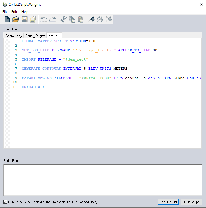
With multiple scripts open at once, the Script Editor eases the creation and management of scripts in Global Mapper.
Python Programming Language Integration
In addition to the Script Editor dialog, Global Mapper Pro now includes Python script integration. Based in Python v3.9, Global Mapper users are now able to automate workflows in the program using the Python programming language.

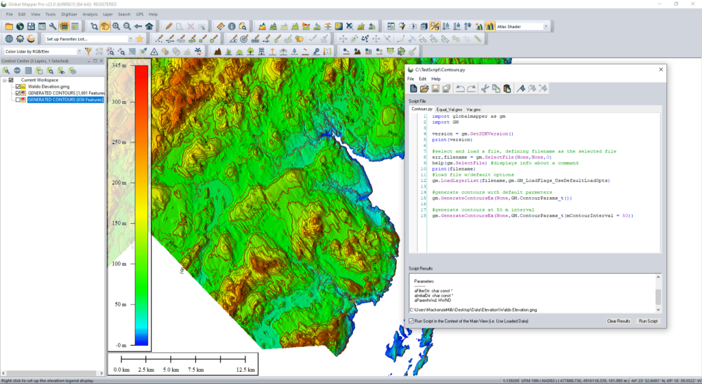
A simple Python script to load a layer and generate contour lines at different intervals is used to automate a repeated task in Global Mapper.
Not replacing Global Mapper Script, but adding to the scripting language options, Python scripts can be written in the new Script Editor or outside of Global Mapper, and run within the Global Mapper interface, via the command line, or in a Python environment.
Automatic Vectorization of Raster Data
On the theme of workflow efficiency, a series of steps to generate vector area features from raster data have been streamlined to extract, create, and smooth area features based on settings applied from a single tool. The new Vectorize Raster tool matches pixels of similar colors or elevation values and generates areas bounding these pixels. To remove the sharp edges of the pixel-derived areas the features are then smoothed based on the user input threshold.

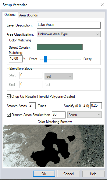
Combining the Create Areas from Equal Values tool and the digitizer smoothing tool, Vectorize Raster allows users to convert pixel-based data into vector areas.
With the automatic vectorization process, users have complete control over the series of steps executed by the tool. Setting a specific color or elevation value for extraction and then consulting the feature creation preview lets users preview what areas of the raster data will be included in the generated vector features.
With a suite of advanced, professional-grade GIS tools, Global Mapper Pro is a worthwhile addition to Global Mapper.
Download a 14-day free trial of the software to explore these new tools in Global Mapper Pro.
Any questions? Contact the team at Blue Marble Geographics.


Related Posts
New Drone Fires Thales Missile in Unmanned Air Combat Milestone
UAS Startup Accelerator Awards 3M in Funding
US Navy Orders Unmanned Tactical Resupply Aircraft