


 Drone Reality Show Follows Surveying of the Pearl River by Land, Water, and Air
by DRONELIFE Staff Writer Ian M. Crosby
Tice Engineering has conducted a surveying project of 150 acres surrounding Jackson, Mississippi’s Pearl River to examine flood zones and inspect Bridge scour. The team’s efforts are documented in “Down to Earth,” a three-episode series demonstrating how real surveyors collect data and convert it into deliverables in spite of challenging and dangerous conditions.
The series follows the Tice team as they scan over and under local infrastructure and under the water bordering the bridge foundations. To complete the job and create a highly detailed 3D surface, Tice will deploy an airborne Lidar drone, terrestrial scanning on the ground, and hydrographic scanning under the water.
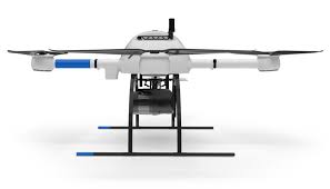
The first episode sees the Tice Team start the survey process by deploying a Z-Boat to scan under the water and the mdLiDAR1000HR to scan from the air. “Tice Engineering was looking for a tool that would help them increase their safety and productivity,” said Microdrones Eastern Sales Manager Chuck Snow. “After a demonstration of our drone technology, they saw how quickly and accurately the mdLiDAR1000HR would help them complete projects, especially like the survey job at the Pearl River.”
“We’ll be using drone LiDAR from the air to collect data for the entire site, terrestrial scanning for under the bridges, and hydrographic scanning under the water to capture the bridge abutments and foundation under the water,” said Tice Engineering President Ryan Tice. “The goal will be to combine the data from all three systems to create a fully developed three-dimensional model that the DOT can use to create a model and look for river scour.”
In the 2nd episode, the team incorporates Terrestrial Scanning to capture points beneath the bridge as the mdLiDAR1000HR completes the project from above. “With the terrestrial scanner, we can pick up all the structure below the bridges, that are in the flood plain,” said Matthew Jones, Professional Surveyor at Tice Engineering. “Then with the drone from above, we’ll collect the bridge decks, railings, and the rest of the infrastructure.”
The mdLiDAR1000HR also helps keep the crew out of harm’s way and complete the work in the field. “The terrain at this site is uneven, sandy, and the slopes slough off when you walk on them,” said Jones. “With the drone, we were able to collect very dense data, of the entire site, without traversing the entire site. Our guys only needed to access the bridge areas for the terrestrial scanning.”
The 3rd episode follows the Tice Team back to their office, where they process and combine the data gathered from all three missions to build one complete surface model of the entire project for the Mississippi Department of Transportation.
“The mdLiDAR1000HR helped us access the entire river area, much easier than conventional topographic survey methods,” said Colt Ratliff, VP, Survey Manager at Tice Engineering. “The river stage is always a major concern, especially with the water levels. This technology ensures we get data from high water, low water, and all the ground cover that’s exposed at that time.”
Read more:
Ian attended Dominican University of California, where he received a BA in English in 2019. With a lifelong passion for writing and storytelling and a keen interest in technology, he is now contributing to DroneLife as a staff writer.


Miriam McNabb is the Editor-in-Chief of DRONELIFE and CEO of JobForDrones, a professional drone services marketplace, and a fascinated observer of the emerging drone industry and the regulatory environment for drones. Miriam has penned over 3,000 articles focused on the commercial drone space and is an international speaker and recognized figure in the industry. Miriam has a degree from the University of Chicago and over 20 years of experience in high tech sales and marketing for new technologies.
For drone industry consulting or writing, Email Miriam.
TWITTER:@spaldingbarker
Subscribe to DroneLife here.


Related Posts
Terra Drone Corporation Expands into U.S. Market through Strategic Investment in Aloft Technologies
Enhancing Photogrammetry Accuracy with Advanced GCPs Integration by SimActive and CompassData
Digital Weather Integration and Scalability of Drone as First Responder (DFR) Programs