


CHC Navigation
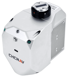 (CHCNAV) has announced the release of the AlphaAir 450 (AA450) LiDAR system. The lightest, most accurate UAV LiDAR system in its class, AlphaAir 450 is a lightweight, compact all-in-one sensor which is easy to use and rapidly deployable in the field.
Widely used for power line inspection, topographic mapping, emergency response, agricultural and forestry surveys, the AlphaAir 450 solution features an internal IMU, GNSS, 3D scanner and camera.
Key aspects of this new solution for capturing geospatial data include:
Lightest unit in its class – LiDAR sensor weight is a constraint for any drone. The lighter the unit, the longer the operating time of the drone, and the greater the productivity. The AlphaAir 450 weighs 1 kg, which is perfectly suited to drone payload requirements. The new compact and lightweight solution that can be easily mounted on UAVs and data capture has become faster and more efficient.
Advanced Accuracy – By combining industrial grade GNSS with a high precision IMU, the AlphaAir 450 can easily achieve absolute accuracy of 5 cm (vertical) and 10 cm (horizontal) for small survey areas, which is typically adequate for most use cases. To further improve precision and accuracy, users can apply adjustment algorithms in the CHCNAV CoPre software.
Industrial Reliability – Featuring IP64 high-level protection, the AlphaAir 450 extends its operating temperature capabilities, down to -20℃ and up to +50℃, in any field environment and increases users’ return on investment by providing more field survey days in a year.
Speaking of the new release Andrei Gorb, Product Manager of CHC Navigation’s Mobile Mapping Division, said; “Despite the fact that the LiDAR scanning is an efficient technology to capture 3D data, it still often remains costly and complex to operate,” explaining, “Taking that into account, we introduce the AlphaAir 450 (AA450), a breakthrough LiDAR scanner, that delivers user-friendly and high-accuracy capabilities at a reasonable price.”


Related Posts
New Drone Fires Thales Missile in Unmanned Air Combat Milestone
UAS Startup Accelerator Awards 3M in Funding
US Navy Orders Unmanned Tactical Resupply Aircraft